![](/images/other/stat-length.png)
![Excursión Senderismo La Chaudière - Mont Faraud - Photo](https://media.geolcdn.com/t/1900/400/ext.pjpeg?maxdim=2&url=https%3A%2F%2Fstatic1.geolcdn.com%2Fsiteimages%2Fupload%2Ffiles%2F1553511878bg_sport_marche.png)
Mont Faraud
TOULAUDIN
Usuario
![Longitud](/images/other/stat-length.png)
Longitud
12 km
![Altitud máxima](https://static1.geolcdn.com/siteimages/upload/files/1508320355ic_sort_altitude_max_24dp.png)
Altitud máxima
1185 m
![Desnivel positivo](https://static1.geolcdn.com/siteimages/upload/files/1508320355ic_sort_den_pos_24dp.png)
Desnivel positivo
645 m
![Km-Effort](/images/other/stat-length.png)
Km-Effort
21 km
![Altitud mínima](https://static1.geolcdn.com/siteimages/upload/files/1508320355ic_sort_altitude_min_24dp.png)
Altitud mínima
732 m
![Desnivel negativo](https://static1.geolcdn.com/siteimages/upload/files/1508320355ic_sort_den_neg_24dp.png)
Desnivel negativo
640 m
![Boucle](https://static1.geolcdn.com/siteimages/upload/files/16400158638029165_repeat_loop_refresh_sync_direction_icon.png)
Boucle
Sí
Fecha de creación :
2019-10-27 08:07:03.33
Última modificación :
2019-10-28 08:04:23.951
![Senderismo](https://static1.geolcdn.com/sitytour/trail-icons/101.png)
4h59
Dificultad : Medio
![Escanee este código QR para abrir la excursión en la aplicación SityTrail](https://capi.geolives.com/qq0zvz2zws4bq2lad0pu/sitytour/trails/2251853/qr.png?size=200)
Aplicación GPS de excursión GRATIS
A propósito
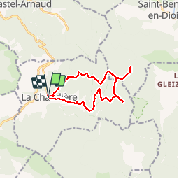
Ruta Senderismo de 12 km a descubrir en Auvergne-Rhône-Alpes, Drôme, La Chaudière. Esta ruta ha sido propuesta por TOULAUDIN.
Descripción
parcours effectué avec club rando Asptt Valence .beau point vue retour
en balcon belle vue sur les 3 becs
Localización
País:
France
Región :
Auvergne-Rhône-Alpes
Departamento/provincia :
Drôme
Municipio :
La Chaudière
Localidad:
Unknown
Salida:(Dec)
Salida:(UTM)
675733 ; 4944531 (31T) N.
Comentarios
Excursiones cerca
![Excursión Senderismo Bourdeaux - Chemin des protestants- Bourdaux - Photo](https://media.geolcdn.com/t/375/260/c9690b91-aa42-47d0-b809-97d643432899.jpg&format=jpg&maxdim=2)
![Senderismo Senderismo](https://static1.geolcdn.com/sitytour/trail-icons/101.png)
Chemin des protestants- Bourdaux
Senderismo
Medio
(1)
Bourdeaux,
Auvergne-Rhône-Alpes,
Drôme,
France
![](/images/other/stat-length.png)
7,9 km | 11,2 km-effort
2h 48min
![](https://static1.geolcdn.com/siteimages/upload/files/16400158638029165_repeat_loop_refresh_sync_direction_icon.png)
Sí
![Excursión Senderismo La Chaudière - Les 3 Becs - Photo](https://media.geolcdn.com/t/375/260/ext.jpg?maxdim=2&url=https%3A%2F%2Fservices.sitytrail.com%2FGeolivesWS%2FDownloadMedia.ashx%3FTrailID%3D218224%26Media%3Dfix__20130901120821.jpg)
![Senderismo Senderismo](https://static1.geolcdn.com/sitytour/trail-icons/101.png)
Les 3 Becs
Senderismo
Medio
(1)
La Chaudière,
Auvergne-Rhône-Alpes,
Drôme,
France
![](/images/other/stat-length.png)
10,3 km | 21 km-effort
5h 37min
![](https://static1.geolcdn.com/siteimages/upload/files/16400158638029165_repeat_loop_refresh_sync_direction_icon.png)
Sí
![Excursión Senderismo La Chaudière - La chaudiere - chapelle des Sadoux - Photo](https://media.geolcdn.com/t/375/260/fe29fe3e-8696-4fc7-af92-f6d3eeb26877.jpg&format=jpg&maxdim=2)
![Senderismo Senderismo](https://static1.geolcdn.com/sitytour/trail-icons/101.png)
La chaudiere - chapelle des Sadoux
Senderismo
Muy fácil
(2)
La Chaudière,
Auvergne-Rhône-Alpes,
Drôme,
France
![](/images/other/stat-length.png)
11,1 km | 18,2 km-effort
3h 47min
![](https://static1.geolcdn.com/siteimages/upload/files/16400158638029165_repeat_loop_refresh_sync_direction_icon.png)
Sí
![Excursión Senderismo Bézaudun-sur-Bîne - 2022-09-26_14h18m42_12295156 - Photo](https://media.geolcdn.com/t/375/260/f11da23a-0048-4e80-a120-e8dd7afb6f22.jpg&format=jpg&maxdim=2)
![Senderismo Senderismo](https://static1.geolcdn.com/sitytour/trail-icons/101.png)
2022-09-26_14h18m42_12295156
Senderismo
Medio
Bézaudun-sur-Bîne,
Auvergne-Rhône-Alpes,
Drôme,
France
![](/images/other/stat-length.png)
6,1 km | 9,9 km-effort
2h 14min
![](https://static1.geolcdn.com/siteimages/upload/files/16400158638029165_repeat_loop_refresh_sync_direction_icon.png)
Sí
![Excursión Senderismo La Chaudière - les 3becs et arches - Photo](https://media.geolcdn.com/t/375/260/97464636-1260-4d97-b592-83a9cda2a983.jpg&format=jpg&maxdim=2)
![Senderismo Senderismo](https://static1.geolcdn.com/sitytour/trail-icons/101.png)
les 3becs et arches
Senderismo
Difícil
La Chaudière,
Auvergne-Rhône-Alpes,
Drôme,
France
![](/images/other/stat-length.png)
15,3 km | 31 km-effort
5h 10min
![](https://static1.geolcdn.com/siteimages/upload/files/16400158638029165_repeat_loop_refresh_sync_direction_icon.png)
Sí
![Excursión Senderismo La Chaudière - les trois becs - Photo](https://media.geolcdn.com/t/375/260/ext.jpg?maxdim=2&url=https%3A%2F%2Fservices.sitytrail.com%2FGeolivesWS%2FDownloadMedia.ashx%3FTrailID%3D997850%26Media%3Dfix__20180701153419.jpg)
![Senderismo Senderismo](https://static1.geolcdn.com/sitytour/trail-icons/101.png)
les trois becs
Senderismo
Medio
La Chaudière,
Auvergne-Rhône-Alpes,
Drôme,
France
![](/images/other/stat-length.png)
11,7 km | 23 km-effort
6h 25min
![](https://static1.geolcdn.com/siteimages/upload/files/16400158638029165_repeat_loop_refresh_sync_direction_icon.png)
Sí
![Excursión Senderismo La Chaudière - La chaudière- chapelle des Sadoux - Photo](https://media.geolcdn.com/t/375/260/6819e1ce-f278-49e2-9b64-8d59d930cfa9.jpg&format=jpg&maxdim=2)
![Senderismo Senderismo](https://static1.geolcdn.com/sitytour/trail-icons/101.png)
La chaudière- chapelle des Sadoux
Senderismo
Medio
La Chaudière,
Auvergne-Rhône-Alpes,
Drôme,
France
![](/images/other/stat-length.png)
11,3 km | 17,6 km-effort
3h 7min
![](https://static1.geolcdn.com/siteimages/upload/files/16400158638029165_repeat_loop_refresh_sync_direction_icon.png)
Sí
![Excursión Senderismo Chastel-Arnaud - montagne de Farraud - Photo](https://media.geolcdn.com/t/375/260/f18555a4-364f-4c22-b353-208a3bb34108.jpg&format=jpg&maxdim=2)
![Senderismo Senderismo](https://static1.geolcdn.com/sitytour/trail-icons/101.png)
montagne de Farraud
Senderismo
Medio
Chastel-Arnaud,
Auvergne-Rhône-Alpes,
Drôme,
France
![](/images/other/stat-length.png)
14,7 km | 26 km-effort
4h 22min
![](https://static1.geolcdn.com/siteimages/upload/files/16400158638029165_repeat_loop_refresh_sync_direction_icon.png)
Sí
![Excursión Senderismo Bézaudun-sur-Bîne - Bèzaudun-sur-Bîne 14km. - Photo](https://media.geolcdn.com/t/375/260/6d673a6d-6a71-4890-ac2e-836b3ed377ad.jpg&format=jpg&maxdim=2)
![Senderismo Senderismo](https://static1.geolcdn.com/sitytour/trail-icons/101.png)
Bèzaudun-sur-Bîne 14km.
Senderismo
Muy difícil
Bézaudun-sur-Bîne,
Auvergne-Rhône-Alpes,
Drôme,
France
![](/images/other/stat-length.png)
14,4 km | 22 km-effort
5h 2min
![](https://static1.geolcdn.com/siteimages/upload/files/16400158638029165_repeat_loop_refresh_sync_direction_icon.png)
Sí